Solstices and equinoxes
In 2023, the June solstice (summer for the Northern Hemisphere, winter for the Southern Hemisphere) takes place at 14:58 UTC today, June 21 (9:58 a.m. CST).
And the December solstice (winter for the Northern Hemisphere, summer for the Southern Hemisphere) will take place at 3:27 UTC on December 22 (9:27 p.m. CST December 21).
A solstice marks the sun’s southernmost and northernmost points in our sky.
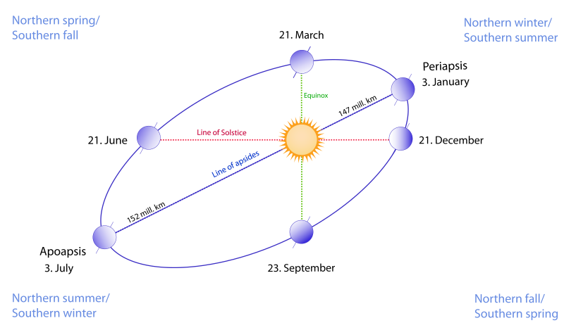
And the fact that Earth’s Northern and Southern Hemispheres have their summers and winters at opposite times of year provides a clue to the reason for Earth’s seasons. That reason is Earth’s 23 1/2-degree tilt on its axis. It’s natural to think our world’s seasons result from our changing distance from the sun. But we’re closer to the sun in northern winter, and farther from the sun in northern summer. So, it’s not Earth’s distance from the sun that causes the seasons to change. Instead, on our tilted world, the angle of sunlight striking your location shifts in a yearly cycle, as we travel around the sun.
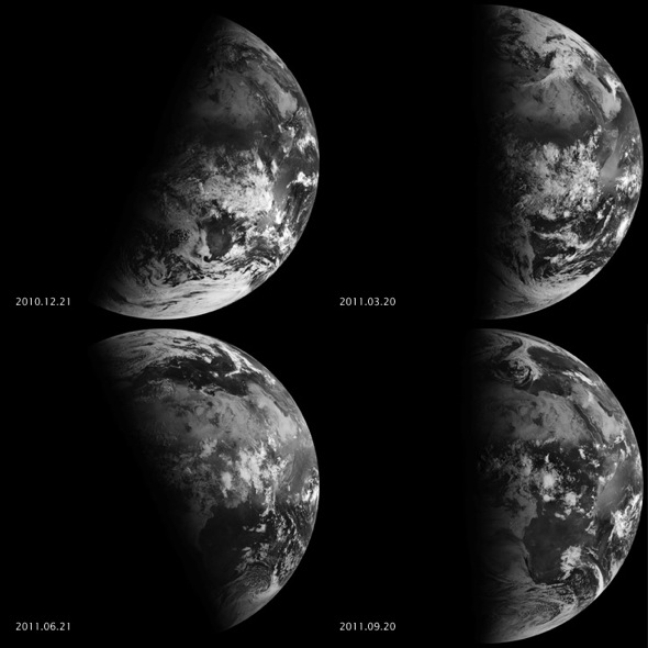
The photos and video on this page – from NASA – show Earth’s solstices and equinoxes from space. They can help you visualize why our seasons unfold as they do, continuously, throughout each year.

Viewing the solstices and equinoxes from space
EUMETSAT‘s Meteosat-9 (a weather satellite) captured the four views above of Earth from geosynchronous orbit in 2010 and 2011. A satellite in geosynchronous orbit stays over the same point on Earth all the time. And the images above show how sunlight fell on the Earth on December 21, 2010 (upper left), March 20, 2011 (upper right), June 21, 2011 (lower left), and September 20, 2011 (lower right). Also, each image was taken at 6:12 a.m. local time.
Around 6 a.m. local time each day, the sun, Earth, and any geosynchronous satellite form a right angle. Thus, affording straight-down view of Earth’s terminator line, that is, the line between our world’s day and night sides. The shape of this line between night and day varies with the seasons. And results in different lengths of days and differing amounts of warming sunshine.
While the line is actually a curve because the Earth is round, satellite images show it in two dimensions only.
On March 20 and September 20, the terminator is a straight north-south line, and the sun sits directly above the equator. Then on December 21, the sun resides directly over the Tropic of Capricorn when viewed from the ground, and sunlight spreads over more of the Southern Hemisphere. Next on June 21, the sun sits above the Tropic of Cancer, spreading more sunlight in the north.

Bottom line: A video from NASA shows how sunlight falls on Earth’s surface during the solstices and equinoxes, as seen by the weather satellite Meteosat-9 in 2010 and 2011.
Help EarthSky keep going! Please donate what you can.
Enjoying EarthSky? Sign up for our free daily newsletter today!
The post Solstices and equinoxes in a video from space first appeared on EarthSky.
0 Commentaires