The National Weather Service is now calling for up to 60 inches (152 cm) of snow – that’s 5 feet of snow – to hit Buffalo, New York, in a days-long snowstorm. The city, just east of Lake Erie, set an all-time record of 56.1 inches (142 cm) in a three-day snowstorm in 2001. This storm might top that. In Oswego, New York, east of Lake Ontario, there were already reports of thundersnow on the morning of November 17. Residents of this region will have to deal with the snowstorm through Sunday, November 20, 2022. The Buffalo Bills were supposed to play a home game against the Cleveland Browns at noon, but it’s now going to be at Ford Field in Detroit.
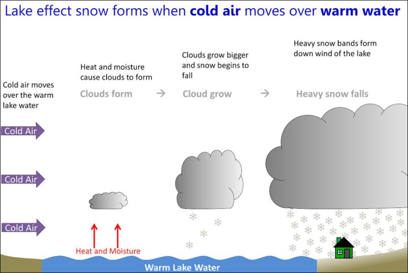
Cities in upstate New York near the Great Lakes are no strangers to lake-effect snow. This phenomenon is a common occurrence throughout the U.S. Great Lakes region during late fall through winter. Lake-effect snow happens when cold air moves over a warmer body of water (such as a Great Lake). Then, the warmth and moisture of the lake transfers to the lower atmosphere. Ultimately, clouds build and release snow downwind. Places on the downwind side of the Great Lakes can easily get 2 to 3 inches (5 to 8 cm) of snow per hour.
The latest @NWSBUFFALO #snowfall map shows the potential for 5 FEET OF SNOW in some areas of #WNY. This is not a typical storm, even for #Buffalo. Please avoid traveling tonight through Sunday.
*The commercial vehicle ban is now in effect on the Thruway.https://t.co/KtbiYYjIOj pic.twitter.com/mIcVUp8RAG
— NYS Thruway Authority (@NYSThruway) November 17, 2022
Due to public safety concerns and out of an abundance of caution in light of the ongoing weather emergency in western New York, Sunday's game against the Browns will be moved to Ford Field in Detroit.
More info: https://t.co/wXQXAZAR39 pic.twitter.com/0RwqGgi4OJ
— Buffalo Bills (@BuffaloBills) November 17, 2022
Lake-effect snow: An interview with Tom Niziol
With this in mind, EarthSky interviewed Tom Niziol, a winter weather expert, a few years back. He said that accurate forecasting of lake-effect snow is a challenge because:
… [Lake-effect snow] occurs on such a small scale, almost on the scale of a summertime thunderstorm. One portion of a neighborhood or city might be under heavy snow, where a few miles away you may be under sunny skies.
He said Buffalo, New York, on the eastern shore of Lake Erie, is notorious for its lake-effect snowstorms. Niziol said cold air moving in from Canada triggers the snowfall.
As that air moves across the warm water of the Great Lakes, heat and moisture from the lake rises up into that air mass. That moisture eventually condenses out into snowflakes. And when we get to the downwind shores, we end up with lake-effect snow.
In addition, Niziol said similar snowstorms happen around the globe. The coasts of the United Kingdom, France, Japan and Korea, for example, get what’s called ocean-effect snow, from cold air moving across warm seas.
So at a whole range of latitudes in the Northern Hemisphere, right around the globe, we see the same activity.
Lake-effect snow causes locally heavy snowstorms
Niziol also gave an earlier example of how dramatic lake-effect snow can be.
In early December 2010, in the western New York area around the city of Buffalo, one of these snow bands set up off Lake Erie. The band was about 8 to 10 miles wide. The northern portion of Buffalo had green grass throughout most of this event. The southern portion of Buffalo, however, only about 10 to 12 miles away, picked up 40 inches of snowfall.
The timing of seasonal snowfalls
He said that lake-effect snow can begin in early fall and continue throughout the winter months.
Early in the fall, we see the same type of activity – cold air moving across a warm body of water – but it’s actually warm enough that we see lake-effect rain showers occur. As we get into November to early December, the air is cold enough to turn that into snow.
But, if the lake freezes over, it can bring a halt to these seasonal snowstorms.
Lake Erie is a very shallow lake. In January it develops a significant amount of ice cover. The ice cover acts as a cap, in a simple way, to limit the amount of heat and moisture that can come through that ice and then modify that air mass.

How to prepare for lake-effect snow
Most importantly, Niziol said that people who experience lake-effect snow should know how to be prepared for an unexpected snowstorm.
Be prepared for winter weather conditions. Have extra clothes in your car, make sure your cellphone is charged, have a shovel in the car, some water, granola bars, extra food as well. Because you never know when you leave the house, even if you have a forecast with you, what it will be like when you drive through one of these snow bands.
In the U.S., lake-effect snow belts may include portions of the Upper Peninsula of Michigan, northern and western portions of the Lower Peninsula of Michigan, northern Indiana, northeastern Ohio, northwestern Pennsylvania and western New York state.
Bottom line: Learn more about what conditions create lake-effect snow and how Buffalo, New York, could see up to 5 feet (1.5 m) of snow by the end of the weekend.
Read more: NASA targets snowstorms in new balloon study
The post Lake-effect snow: Buffalo poised to set records first appeared on EarthSky.
0 Commentaires